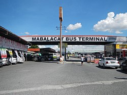
Mabalacat
Mabalacat | |
|---|---|
Ciudad | |
 | |
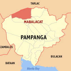
 Mapa de Pampanga con Mabalacat resaltado | |
 | |
| Coordenadas: 15°13'N, 120°35'E | |
| Nación | Filipinas |
| Región | Luzon Central (Región III) |
| Provincia | Pampanga |
| Número de barangay | 27 |
| Fundación | 1712 |
| Gobierno | |
| • Type | ayuntamiento |
| • Mayor | Crisostomo Garbo |
| • Electorado | Error en la secuencia de órdenes: la función «getValue» no existe. votantes (9 Mayo 2022) |
| Superficie | |
| • Total | 83,18 km2 (32,12 sq mi) |
| Elevation | 166 m (545 ft) |
| Populación (1 Mayo 2020) | |
| • Total | 293,244 |
| • Densidad | 3,5/km2 (9,1/sq mi) |
| • Hogares | 74,707 |
| Huso horario | UTC+8 (PST) |
| Código postal | 2010 |
| PSGC | |
| Código telefonico | 45 |
| Lenguaje nativo | pampango Mag-antsi Tagalog |
| Website | http://mabalacatcity.gov.ph/ |
Mabalacat el tercera clase clase de ciudad na provincia de Pampanga, Filipinas. Tiene este zona de 83.18 kilometro cuadrado.
Comporme del 1 Mayo 2020 censo este tiene papulidad de 293,244 personas y 74,707 hogares. El designada codigo postal 2010 y PSGC 035409000.
Barangay[revisa | revisa codigo]
|
|
Demografía[revisa | revisa codigo]
| Año | Populación | ±% p.a. |
|---|---|---|
| 1903 | 7049 | — |
| 1918 | 9378 | +1.92% |
| 1939 | 20 560 | +3.81% |
| 1948 | 25 281 | +2.32% |
| 1960 | 31 752 | +1.92% |
| 1970 | 55 897 | +5.81% |
| 1975 | 69 874 | +4.58% |
| 1980 | 80 966 | +2.99% |
| 1990 | 121 115 | +4.11% |
| 1995 | 129 990 | +1.33% |
| 2000 | 171 045 | +6.06% |
| 2007 | 203 307 | +2.41% |
| 2010 | 215 610 | +2.16% |
| 2015 | 250 799 | +2.92% |
| 2020 | 293 244 | +3.12% |
| Ref: Autoridad de Estadísticas de Filipinas[3][4][5][6] | ||
Referencias[revisa | revisa codigo]
- ↑ «Province: Pampanga». PSGC Interactive. Quezon City, Philippines: Philippine Statistics Authority. Consultado el Diciembre 17, 2016.
- ↑ «PSA Releases the 2018 Municipal and City Level Poverty Estimates» (15 Diciembre 2021).
- ↑ Census of Population (2015). "Region III (Central Luzon)". Total Population by Province, City, Municipality and Barangay. Philippine Statistics Authority.
- ↑ Census of Population and Housing (2010). "Region III (Central Luzon)". Total Population by Province, City, Municipality and Barangay. NSO.
- ↑ Censuses of Population (1903–2007). "Region III (Central Luzon)". Table 1. Population Enumerated in Various Censuses by Province/Highly Urbanized City: 1903 to 2007. NSO.
- ↑ «Province of Pampanga». Municipality Population Data. Local Water Utilities Administration Research Division. Consultado el Diciembre 17, 2016.
Enlaces externos[revisa | revisa codigo]
- PhilAtlas.com
- Philippine Standard Geographic Code
- Local Governance Performance Management System
- mabalacatcity
.gov .ph
| San Fernando (cabecera) | |
| Municipalidad: | Apalit ▪ Arayat ▪ Bácolor ▪ Candaba ▪ Floridablanca ▪ Guagua ▪ Lubao ▪ Macabebe ▪ Magalang ▪ Masantol ▪ Mexico ▪ Minalin ▪ Pórac ▪ San Luis ▪ San Simon ▪ Santa Ana ▪ Santa Rita ▪ Santo Tomas ▪ Sasmuan |
| Ciudad: | Ángeles ▪ Mabalacat ▪ San Fernando |
