Hinunangan
Apariencia
(Redirigido desde «Hinunangan, Southern Leyte»)
Hinunangan | |
|---|---|
Municipalidad | |
 | |
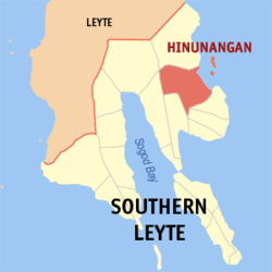
 Mapa de Southern Leyte con Hinunangan resaltado | |
 | |
| Coordinates: 10°24'N, 125°12'E | |
| Nación | Filipinas |
| Región | Visayas Oriental (Región VIII) |
| Provincia | Southern Leyte |
| Número de barangay | 40 |
| Gobierno | |
| • Type | consejo municipal |
| • Electorado | 21 548 votantes (9 Mayo 2022) |
| Area | |
• Total | 170,58 kilómetro cuadrado km2 (Formatting error: invalid input when rounding sq mi) |
| Elevation | 4,8 metro m (Bad rounding hereFormatting error: invalid input when rounding ft) |
| Population (1 Mayo 2020) | |
• Total | 29 149 |
| • Hogares | 7402 |
| Economía | |
| • Clase de ingresos | es un tercera clase de municipalidad |
| • Incidencia de la pobreza | 21,94% (2021)[2] |
| • Ingresos | ₱ 138 166 256,5962 202 554,4867 452 039,6380 635 620,6087 705 409,31103 591 288,805 857 048,168 295 186,95126 442 250,85151 944 928,49195 392 790,95 (2020) |
| • Activos | ₱ 253 993 689,45149 487 218,501 470 598,90123 327 949,03114 696 643,91144 136 711,80198 211 643,62235 240 168,73320 079 832,39380 594 761,97 (2020) |
| • Pasivos | ₱ 97 005 813,8883 190 192,1765 363 963,2661 390 574,2370 713 618,9266 571 934,6781 806 359,3585 061 521,7791 647 517,30127 495 631,59125 420 942,40 (2020) |
| • Gastos | ₱ 135 991 603,39102 144 873,9064 267 280,2272 626 619,7582 839 067,9780 265 433,8982 652 684,0086 962 971,24114 662 968,79130 146 507,09157 981 912,50 (2020) |
| Time zone | UTC+8 (PST) |
| Código postal | 6608 |
| PSGC | |
| Código telefonico | 53 |
| Clima | clima ecuatorial |
| Lenguaje nativo | dialecto boholano Cebuano Tagalog |
Hinunangan es un tercera clase de municipalidad na provincia de Southern Leyte, Filipinas. Tiene este zona de 170.58 kilómetro cuadrado kilometro cuadrado. Comporme del 1 Mayo 2020 censo este tiene papulidad de 29,149 personas y 7,402 hogares. El designada codigo postal 6608 y PSGC 086403000.
Barangay
[revisa | revisa codigo]
|
|
|
Demografía
[revisa | revisa codigo]| Año | Populación | ±% p.a. |
|---|---|---|
| 1903 | 8574 | — |
| 1918 | 11 491 | +1.97% |
| 1939 | 16 983 | +1.88% |
| 1948 | 17 556 | +0.37% |
| 1960 | 12 665 | −2.68% |
| 1970 | 16 142 | +2.45% |
| 1975 | 18 648 | +2.94% |
| 1980 | 20 568 | +1.98% |
| 1990 | 22 454 | +0.88% |
| 1995 | 22 170 | −0.24% |
| 2000 | 25 016 | +2.62% |
| 2007 | 27 712 | +1.42% |
| 2010 | 28 415 | +0.92% |
| 2015 | 29 976 | +1.02% |
| 2020 | 29 149 | −0.55% |
| Ref: Autoridad de Estadísticas de Filipinas[3][4][5][6] | ||
Referencias
[revisa | revisa codigo]- ↑
"Province: Southern Leyte". PSGC Interactive. Quezon City, Philippines: Philippine Statistics Authority. Retrieved Diciembre 17, 2016.
{{cite web}}: Check date values in:|accessdate=(help) - ↑ "PSA Releases the 2021 City and Municipal Level Poverty Estimates". Autoridad de Estadística de Filipinas. 2 Abril 2024. Retrieved 28 Abril 2024.
- ↑
Census of Population (2015). "Region VIII (Eastern Visayas)". Total Population by Province, City, Municipality and Barangay. Philippine Statistics Authority.
{{cite encyclopedia}}: External link in|chapterurl=|chapterurl=ignored (|chapter-url=suggested) (help)CS1 maint: numeric names: authors list (link) - ↑
Census of Population and Housing (2010). "Region VIII (Eastern Visayas)". Total Population by Province, City, Municipality and Barangay. NSO.
{{cite encyclopedia}}: External link in|chapterurl=|chapterurl=ignored (|chapter-url=suggested) (help)CS1 maint: numeric names: authors list (link) - ↑
Censuses of Population (1903–2007). "Region VIII (Eastern Visayas)". Table 1. Population Enumerated in Various Censuses by Province/Highly Urbanized City: 1903 to 2007. NSO.
{{cite encyclopedia}}: External link in|chapterurl=|chapterurl=ignored (|chapter-url=suggested) (help)CS1 maint: numeric names: authors list (link) CS1 maint: url-status (link) - ↑
"Province of Southern Leyte". Municipality Population Data. Local Water Utilities Administration Research Division. Retrieved Diciembre 17, 2016.
{{cite web}}: Check date values in:|accessdate=(help)
Enlaces externos
[revisa | revisa codigo]| Maasin (cabecera) | |
| Municipalidad: | Anahawan ▪ Bontoc ▪ Hinunangan ▪ Hinundayan ▪ Libagon ▪ Liloan ▪ Limasawa ▪ Macrohon ▪ Malitbog ▪ Padre Burgos ▪ Pintuyan ▪ Saint Bernard ▪ San Francisco ▪ San Juan ▪ San Ricardo ▪ Silago ▪ Sogod ▪ Tomas Oppus |
| Ciudad: | Maasin |
Maga Categoria:
- Páginas con argumentos formatnum no numéricos
- Páginas que utilizan la extensión JsonConfig
- CS1 errors: dates
- CS1 errors: unsupported parameter
- CS1 errors: external links
- CS1 maint: numeric names: authors list
- CS1 maint: url-status
- Article with short description
- Short description is different from Wikidata
- Pages using deprecated image syntax
- Infobox mapframe without OSM relation ID on Wikidata
- Pages with bad rounding precision
- Los municipios del Southern Leyte
- Páginas que usan la extensión Kartographer
