Santa Barbara, Pangasinan
Apariencia
Santa Barbara | |
|---|---|
Municipalidad | |
 | |
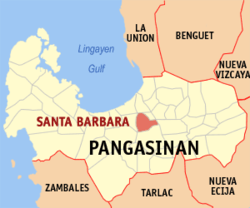
 Mapa de Pangasinan con Santa Barbara resaltado | |
 | |
| Coordenadas: 16°0'11.02"N, 120°24'2.99"E | |
| Nación | Filipinas |
| Región | Región de Ilocos (Región I) |
| Provincia | Pangasinan |
| Número de barangay | 29 |
| Fundación | 30 Octubre 1741 |
| Gobierno | |
| • Type | consejo municipal |
| • Electorado | Error en la secuencia de órdenes: la función «getValue» no existe. votantes (9 Mayo 2022) |
| Superficie | |
| • Total | 61,37 km2 (23,70 sq mi) |
| Elevation | 9 m (30 ft) |
| Populación (1 Mayo 2020) | |
| • Total | 92,187 |
| • Densidad | 1,5/km2 (3,9/sq mi) |
| • Hogares | 21,809 |
| Economía | |
| • Clase de ingresos | el primera clase de municipalidad |
| • Incidencia de la pobreza | Error en la secuencia de órdenes: la función «getValue» no existe.% (Error: fecha y hora no válidas.)[2] |
| • Ingresos | ₱ <strong4a4df3e5">Error (Error: fecha y hora no válidas.) |
| • Activos | ₱ <strong4a4df3e5">Error (Error: fecha y hora no válidas.) |
| • Pasivos | ₱ <strong4a4df3e5">Error (Error: fecha y hora no válidas.) |
| • Gastos | ₱ <strong4a4df3e5">Error (Error: fecha y hora no válidas.) |
| Huso horario | UTC+8 (PST) |
| Código postal | 2419 |
| PSGC | |
| Código telefonico | 75 |
| Lenguaje nativo | pangasinense ilocano Tagalog |
| Website | http://www.stabarbara-pangasinan.ph/ |
Santa Barbara el primera clase de municipalidad na provincia de Pangasinan, Filipinas. Tiene este zona de 61.37 kilometro cuadrado.
Comporme del 1 Mayo 2020 censo este tiene papulidad de 92,187 personas y 21,809 hogares. El designada codigo postal 2419 y PSGC 015538000.
Barangay
[revisa | revisa codigo]
|
|
Demografía
[revisa | revisa codigo]| Año | Populación | ±% p.a. |
|---|---|---|
| 1903 | 10 367 | — |
| 1918 | 13 263 | +1.66% |
| 1939 | 15 125 | +0.63% |
| 1948 | 19 570 | +2.90% |
| 1960 | 24 005 | +1.72% |
| 1970 | 30 580 | +2.45% |
| 1975 | 34 418 | +2.40% |
| 1980 | 37 001 | +1.46% |
| 1990 | 48 056 | +2.65% |
| 1995 | 54 116 | +2.25% |
| 2000 | 64 261 | +3.75% |
| 2007 | 73 025 | +1.78% |
| 2010 | 76 637 | +1.77% |
| 2015 | 82 012 | +1.30% |
| 2020 | 92 187 | +2.33% |
| Ref: Autoridad de Estadísticas de Filipinas[3][4][5][6] | ||
Referencias
[revisa | revisa codigo]- ↑ «Province: Pangasinan». PSGC Interactive. Quezon City, Philippines: Philippine Statistics Authority. Consultado el Diciembre 17, 2016.
- ↑ «PSA Releases the 2021 City and Municipal Level Poverty Estimates» (2 Abril 2024).
- ↑ Census of Population (2015). "Region I (Ilocos Region)". Total Population by Province, City, Municipality and Barangay. Philippine Statistics Authority.
- ↑ Census of Population and Housing (2010). "Region I (Ilocos Region)". Total Population by Province, City, Municipality and Barangay. NSO.
- ↑ Censuses of Population (1903–2007). "Region I (Ilocos Region)". Table 1. Population Enumerated in Various Censuses by Province/Highly Urbanized City: 1903 to 2007. NSO.
- ↑ «Province of Pangasinan». Municipality Population Data. Local Water Utilities Administration Research Division. Consultado el Diciembre 17, 2016.
Enlaces externos
[revisa | revisa codigo]- PhilAtlas.com
- Philippine Standard Geographic Code
- Local Governance Performance Management System
- www
.stabarbara-pangasinan .ph
| Lingayen (cabecera) | |
| Municipalidad: | Agno ▪ Aguilar ▪ Alcala ▪ Anda ▪ Asingan ▪ Balungao ▪ Bani ▪ Basista ▪ Bautista ▪ Bayambang ▪ Binalonan ▪ Binmaley ▪ Bolinao ▪ Bugallon ▪ Burgos ▪ Calasiao ▪ Dasol ▪ Infanta ▪ Labrador ▪ Laoac ▪ Lingayen ▪ Mabini ▪ Malasiqui ▪ Manaoag ▪ Mangaldan ▪ Mangatarem ▪ Mapandan ▪ Natividad ▪ Pozorrubio ▪ Rosales ▪ San Fabian ▪ San Jacinto ▪ San Manuel ▪ San Nicolas ▪ San Quintin ▪ Santa Barbara ▪ Santa Maria ▪ Santo Tomás ▪ Sison ▪ Sual ▪ Tayug ▪ Umingan ▪ Urbiztondo ▪ Villasis |
| Ciudad: | Alaminos ▪ Dagupán ▪ San Carlos ▪ Urdaneta |
