Julita
Apariencia
(Redirigido desde «Julita, Leyte»)
Julita | |
|---|---|
Municipalidad | |
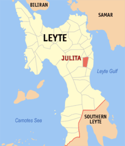
 Mapa de Leyte con Julita resaltado | |
 | |
| Coordinates: 10°58'23"N, 124°57'44"E | |
| Nación | Filipinas |
| Región | Visayas Oriental (Región VIII) |
| Provincia | Leyte |
| Número de barangay | 26 |
| Gobierno | |
| • Type | consejo municipal |
| • Electorado | 11 536 votantes (9 Mayo 2022) |
| Area | |
• Total | 53,30 kilómetro cuadrado km2 (Formatting error: invalid input when rounding sq mi) |
| Elevation | 39 metro m (Bad rounding hereFormatting error: invalid input when rounding ft) |
| Population (1 Mayo 2020) | |
• Total | 15 598 |
| • Hogares | 4372 |
| Economía | |
| • Clase de ingresos | es un aca cinco clase de municipalidad |
| • Incidencia de la pobreza | 32,13% (2021)[2] |
| • Ingresos | ₱ 81 025 660,85 (2020) |
| • Activos | ₱ 302 326 003,12 (2020) |
| • Pasivos | ₱ 48 171 055,80 (2020) |
| • Gastos | ₱ 83 512 276,85 (2020) |
| Time zone | UTC+8 (PST) |
| Código postal | 6506 |
| PSGC | |
| Código telefonico | 53 |
| Clima | clima ecuatorial |
| Lenguaje nativo | samareño Tagalog |
Julita es un aca cinco clase de municipalidad na provincia de Leyte, Filipinas. Tiene este zona de 53.30 kilómetro cuadrado kilometro cuadrado. Comporme del 1 Mayo 2020 censo este tiene papulidad de 15,598 personas y 4,372 hogares. El designada codigo postal 6506 y PSGC 0803725000.
Barangay
[revisa | revisa codigo]
|
|
Demografía
[revisa | revisa codigo]| Año | Populación | ±% p.a. |
|---|---|---|
| 1960 | 9112 | — |
| 1970 | 9307 | +0.21% |
| 1975 | 9445 | +0.30% |
| 1980 | 9724 | +0.58% |
| 1990 | 9944 | +0.22% |
| 1995 | 11 671 | +3.05% |
| 2000 | 12 096 | +0.77% |
| 2007 | 12 310 | +0.24% |
| 2010 | 13 307 | +2.87% |
| 2015 | 15 114 | +2.45% |
| 2020 | 15 598 | +0.62% |
| Ref: Autoridad de Estadísticas de Filipinas[3][4][5][6] | ||
Referencias
[revisa | revisa codigo]- ↑
"Province:". PSGC Interactive. Quezon City, Philippines: Philippine Statistics Authority. Retrieved Diciembre 17, 2016.
{{cite web}}: Check date values in:|accessdate=(help) - ↑ "PSA Releases the 2021 City and Municipal Level Poverty Estimates". Autoridad de Estadística de Filipinas. 2 Abril 2024. Retrieved 28 Abril 2024.
- ↑
Census of Population (2015). "Region VIII (Eastern Visayas)". Total Population by Province, City, Municipality and Barangay. Philippine Statistics Authority.
{{cite encyclopedia}}: External link in|chapterurl=|chapterurl=ignored (|chapter-url=suggested) (help)CS1 maint: numeric names: authors list (link) - ↑
Census of Population and Housing (2010). "Region VIII (Eastern Visayas)". Total Population by Province, City, Municipality and Barangay. NSO.
{{cite encyclopedia}}: External link in|chapterurl=|chapterurl=ignored (|chapter-url=suggested) (help)CS1 maint: numeric names: authors list (link) - ↑
Censuses of Population (1903–2007). "Region VIII (Eastern Visayas)". Table 1. Population Enumerated in Various Censuses by Province/Highly Urbanized City: 1903 to 2007. NSO.
{{cite encyclopedia}}: External link in|chapterurl=|chapterurl=ignored (|chapter-url=suggested) (help)CS1 maint: numeric names: authors list (link) CS1 maint: url-status (link) - ↑
"Province of". Municipality Population Data. Local Water Utilities Administration Research Division. Retrieved Diciembre 17, 2016.
{{cite web}}: Check date values in:|accessdate=(help)
Enlaces externos
[revisa | revisa codigo]
| Tacloban (cabecera) | |
| Municipalidad | Abuyog ▪ Alangalang ▪ Albuera ▪ Babatngon ▪ Barugo ▪ Bato ▪ Burauen ▪ Calubian ▪ Capoocan ▪ Carigara ▪ Dagami ▪ Dulag ▪ Hilongos ▪ Hindang ▪ Inopacan ▪ Isabel ▪ Jaro ▪ Javier ▪ Julita ▪ Kananga ▪ La Paz ▪ Leyte ▪ MacArthur ▪ Mahaplag ▪ Matag-ob ▪ Matalom ▪ Mayorga ▪ Merida ▪ Palo ▪ Palompon ▪ Pastrana ▪ San Isidro ▪ San Miguel ▪ Santa Fe ▪ Tabango ▪ Tabontabon ▪ Tanauan ▪ Tolosa ▪ Tunga ▪ Villaba |
| Ciudad: | Baybay ▪ Ormoc ▪ Tacloban |
Maga Categoria:
- Páginas con argumentos formatnum no numéricos
- Páginas que utilizan la extensión JsonConfig
- CS1 errors: dates
- CS1 errors: unsupported parameter
- CS1 errors: external links
- CS1 maint: numeric names: authors list
- CS1 maint: url-status
- Article with short description
- Short description is different from Wikidata
- Pages with bad rounding precision
- Los municipios del Leyte
- Páginas que usan la extensión Kartographer
