La Carlota
Apariencia
La Carlota | |
|---|---|
Ciudad | |
 | |
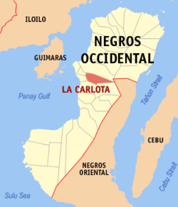
 Mapa de Negros Occidental con La Carlota resaltado | |
 | |
| Coordenadas: 10°25'N, 122°55'E | |
| Nación | Filipinas |
| Región | Visayas Occidental (Región VI) |
| Provincia | Negros Occidental |
| Número de barangay | 14 |
| Fundación | 15 Octubre 1869 |
| Gobierno | |
| • Type | ayuntamiento |
| • Electorado | Error en la secuencia de órdenes: la función «getValue» no existe. votantes (9 Mayo 2022) |
| Superficie | |
| • Total | 137,29 km2 (53,01 sq mi) |
| Elevation | 77 m (253 ft) |
| Populación (1 Mayo 2020) | |
| • Total | 66,664 |
| • Densidad | 0,49/km2 (1,3/sq mi) |
| • Hogares | 16,508 |
| Economía | |
| • Clase de ingresos | el ika cuatro clase de ciudad |
| • Incidencia de la pobreza | Error en la secuencia de órdenes: la función «getValue» no existe.% (Error: fecha y hora no válidas.)[2] |
| • Ingresos | ₱ <strong4a4df3e5">Error (Error: fecha y hora no válidas.) |
| • Activos | ₱ <strong4a4df3e5">Error (Error: fecha y hora no válidas.) |
| • Pasivos | ₱ <strong4a4df3e5">Error (Error: fecha y hora no válidas.) |
| • Gastos | ₱ <strong4a4df3e5">Error (Error: fecha y hora no válidas.) |
| Huso horario | UTC+8 (PST) |
| Código postal | 6130 |
| PSGC | |
| Código telefonico | 34 |
| Lenguaje nativo | Hiligueino Tagalog |
| Website | http://www.lacarlotacity.net/ |
La Carlota el ika cuatro clase de ciudad na provincia de Negros Occidental, Filipinas. Tiene este zona de 137.29 kilometro cuadrado.
Comporme del 1 Mayo 2020 censo este tiene papulidad de 66,664 personas y 16,508 hogares. El designada codigo postal 6130 y PSGC 064516000.
Barangay
[revisa | revisa codigo]- Ara-al
- Ayungon
- Balabag
- Batuan
- Consuelo
- Cubay
- Haguimit
- La Granja
- Nagasi
- Barangay I (Pob.)
- Barangay II (Pob.)
- Barangay III (Pob.)
- San Miguel
- Yubo
Demografía
[revisa | revisa codigo]| Año | Populación | ±% p.a. |
|---|---|---|
| 1903 | 13 097 | — |
| 1918 | 20 410 | +3.00% |
| 1939 | 26 084 | +1.17% |
| 1948 | 45 789 | +6.45% |
| 1960 | 56 772 | +1.81% |
| 1970 | 38 321 | −3.85% |
| 1975 | 40 984 | +1.36% |
| 1980 | 45 812 | +2.25% |
| 1990 | 56 443 | +2.11% |
| 1995 | 56 414 | −0.01% |
| 2000 | 56 408 | −0.00% |
| 2007 | 63 584 | +1.67% |
| 2010 | 63 852 | +0.15% |
| 2015 | 64 469 | +0.18% |
| 2020 | 66 664 | +0.66% |
| Ref: Autoridad de Estadísticas de Filipinas[3][4][5][6] | ||
Referencias
[revisa | revisa codigo]- ↑ «Province:». PSGC Interactive. Quezon City, Philippines: Philippine Statistics Authority. Consultado el Diciembre 17, 2016.
- ↑ «PSA Releases the 2021 City and Municipal Level Poverty Estimates» (2 Abril 2024).
- ↑ Census of Population (2015). "Region VI (Western Visayas)". Total Population by Province, City, Municipality and Barangay. Philippine Statistics Authority.
- ↑ Census of Population and Housing (2010). "Region VI (Western Visayas)". Total Population by Province, City, Municipality and Barangay. NSO.
- ↑ Censuses of Population (1903–2007). "Region VI (Western Visayas)". Table 1. Population Enumerated in Various Censuses by Province/Highly Urbanized City: 1903 to 2007. NSO.
- ↑ «Province of». Municipality Population Data. Local Water Utilities Administration Research Division. Consultado el Diciembre 17, 2016.
Enlaces externos
[revisa | revisa codigo]- PhilAtlas.com
- Philippine Standard Geographic Code
- Local Governance Performance Management System
- www
.lacarlotacity .net
| Bangued (cabecera) | |
| Municipalidad: | Binalbagan ▪ Calatrava ▪ Candoní ▪ Cauayan ▪ Enrique B. Magalona ▪ Hinigaran ▪ Hinoba-an ▪ Ilog ▪ Isabela ▪ La Castellana ▪ Manapla ▪ Moises Padilla ▪ Murcia ▪ Pontevedra ▪ Pulupandan ▪ Salvador Benedicto ▪ San Enrique ▪ Toboso ▪ Valladolid |
| Ciudad: | Bacolod ▪ Bago ▪ Cadiz ▪ Escalante ▪ Himamaylan ▪ Kabankalan ▪ La Carlota ▪ Sagay ▪ San Carlos ▪ Silay ▪ Sipalay ▪ Talisay ▪ Victorias |
