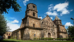
Miagao
Apariencia
Miagao | |
|---|---|
Municipalidad | |
 | |
 Mapa de Provincia de Iloílo con Miagao resaltado | |
 | |
| Coordenadas: 10°38'39.12"N, 122°14'6.72"E | |
| Nación | Filipinas |
| Región | Provincia de Iloílo |
| Provincia | Provincia de Iloílo |
| Número de barangay | 119 |
| Gobierno | |
| • Type | consejo municipal |
| • Electorado | Error en la secuencia de órdenes: la función «getValue» no existe. votantes (9 Mayo 2022) |
| Superficie | |
| • Total | 156,80 km2 (60,54 sq mi) |
| Elevation | 29 m (95 ft) |
| Populación (1 Mayo 2020) | |
| • Total | 68,115 |
| • Densidad | 0,43/km2 (1,1/sq mi) |
| • Hogares | 16,006 |
| Economía | |
| • Clase de ingresos | el primera clase de municipalidad |
| • Incidencia de la pobreza | Error en la secuencia de órdenes: la función «getValue» no existe.% (Error: fecha y hora no válidas.)[2] |
| • Ingresos | ₱ <strong4a4df3e5">Error (Error: fecha y hora no válidas.) |
| • Activos | ₱ <strong4a4df3e5">Error (Error: fecha y hora no válidas.) |
| • Pasivos | ₱ <strong4a4df3e5">Error (Error: fecha y hora no válidas.) |
| • Gastos | ₱ <strong4a4df3e5">Error (Error: fecha y hora no válidas.) |
| Huso horario | UTC+8 (PST) |
| Código postal | 5023 |
| PSGC | |
| Código telefonico | 33 |
| Lenguaje nativo | harayo Hiligueino Tagalog |
| Website | http://www.miagao.gov.ph/ |
Miagao el primera clase de municipalidad na provincia de Provincia de Iloílo, Filipinas. Tiene este zona de 156.80 kilometro cuadrado.
Comporme del 1 Mayo 2020 censo este tiene papulidad de 68,115 personas y 16,006 hogares. El designada codigo postal 5023 y PSGC 063030000.
Barangay
[revisa | revisa codigo]
|
|
|
Demografía
[revisa | revisa codigo]| Año | Populación | ±% p.a. |
|---|---|---|
| 1903 | 20 656 | — |
| 1918 | 24 556 | +1.16% |
| 1939 | 30 179 | +0.99% |
| 1948 | 30 143 | −0.01% |
| 1960 | 32 117 | +0.53% |
| 1970 | 37 585 | +1.58% |
| 1975 | 40 603 | +1.56% |
| 1980 | 45 816 | +2.44% |
| 1990 | 51 738 | +1.22% |
| 1995 | 52 276 | +0.19% |
| 2000 | 57 092 | +1.91% |
| 2007 | 60 498 | +0.80% |
| 2010 | 64 545 | +2.38% |
| 2015 | 67 565 | +0.87% |
| 2020 | 68 115 | +0.16% |
| Ref: Autoridad de Estadísticas de Filipinas[3][4][5][6] | ||
Referencias
[revisa | revisa codigo]- ↑ «Province: Iloilo». PSGC Interactive. Quezon City, Philippines: Philippine Statistics Authority. Consultado el Diciembre 17, 2016.
- ↑ «PSA Releases the 2021 City and Municipal Level Poverty Estimates» (2 Abril 2024).
- ↑ Census of Population (2015). "Region VI (Western Visayas)". Total Population by Province, City, Municipality and Barangay. Philippine Statistics Authority.
- ↑ Census of Population and Housing (2010). "Region VI (Western Visayas)". Total Population by Province, City, Municipality and Barangay. NSO.
- ↑ Censuses of Population (1903–2007). "Region VI (Western Visayas)". Table 1. Population Enumerated in Various Censuses by Province/Highly Urbanized City: 1903 to 2007. NSO.
- ↑ «Province of Iloilo». Municipality Population Data. Local Water Utilities Administration Research Division. Consultado el Diciembre 17, 2016.
Enlaces externos
[revisa | revisa codigo]- PhilAtlas.com
- Philippine Standard Geographic Code
- Local Governance Performance Management System
- www
.miagao .gov .ph
| Ciudad de Iloilo (cabecera) | |
| Municipalidad: | Ajuy ▪ Alimodian ▪ Anilao ▪ Badiangan ▪ Balasan ▪ Banate ▪ Barotac Nuevo ▪ Barotac Viejo ▪ Batad ▪ Bingawan ▪ Cabatuan ▪ Calinog ▪ Carles ▪ Concepcion ▪ Dingle ▪ Dueñas ▪ Dumangas ▪ Estancia ▪ Guimbal ▪ Igbaras ▪ Janiuay ▪ Lambunao ▪ Leganes ▪ Lémery ▪ Leon ▪ Maasin ▪ Miagao ▪ Mina ▪ New Lucena ▪ Otón ▪ Pavia ▪ Pototan ▪ San Dionisio ▪ San Enrique ▪ San Joaquin ▪ San Miguel ▪ San Rafael ▪ Santa Barbara ▪ Sara ▪ Tigbauan ▪ Tubungan ▪ Zarraga |
| Ciudad: | Ciudad de Iloilo ▪ Passi |
